
VRGeoscience — turning digital outcrops into geological understanding
VRGS (Virtual Reality Geological Studio) is the integrated software to visualise, interpret and analyse 3D geological models. On the desktop, in VR, and now powered by AI.
Developed by geoscientists · Proven in peer-reviewed research and industry
Exploring a high-resolution digital outcrop model in VRGS — from whole-quarry overview to centimetre-scale detail.
From digital outcrops to geological interpretation
VRGS is designed for geoscientists who need to extract robust, quantitative insights from complex 3D geological data. VRGS enables you to:
- Interpret geological structures directly on high-resolution models
- Work efficiently with large, complex datasets
- Visualise and assess 3D datasets in VR as well as desktop mode
- Make accurate geological measurements in 3 dimensions
The result is better geological understanding, improved interpretation confidence, and more defensible outcomes.
Intelligence built into interpretation
VRGS brings AI to the interpretation surface itself. Your data, your project, your outcrop.
Athos : your interpretation copilot
A project-aware AI assistant inside VRGS. Ask questions about your outcrop, your interpretation and your data in plain language — and get answers grounded in your own project.
AI feature extraction
VRGS machine-learning extracts geological features straight from outcrop imagery, turning hours of manual digitising into a guided, AI-assisted workflow.
outcrop.io : an AI-native data platform
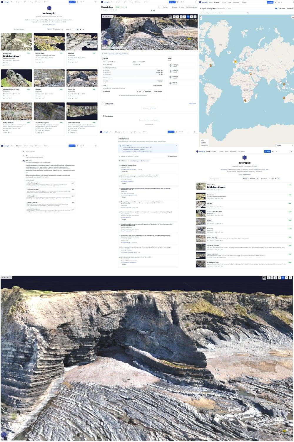
Publish your models to a FAIR repository with a built-in MCP server and semantic (RAG) indexing, so your outcrops are findable, queryable and machine-readable.
Explore outcrop.ioVRGS is built for real geological workflows
High-performance visualisation and a comprehensive set of geological interpretation tools all within VRGS.
3D visualisation
Visualise massive meshes and point clouds from photogrammetry, LiDAR and Gaussian splats, with rendering tuned for geological datasets.
Structural analysis
Map bedding, faults and fractures, then quantify them with stereonets, Kamb and KDE contouring, and slip- and dilation-tendency analysis.
Sedimentology
Build measured sections, correlations and detailed sedimentological logs, fully integrated with your digital outcrop model.
Quantitative outputs
Generate quantitative results, orientations, statistics and DFN inputs, and export them to your downstream modelling and reporting.
Desktop & VR
Switch between desktop analysis and immersive VR on the same dataset, with identical, consistent results across both.
Collaboration & training
Build virtual field trips and shared experiences for teaching, training and collaborative interpretation.
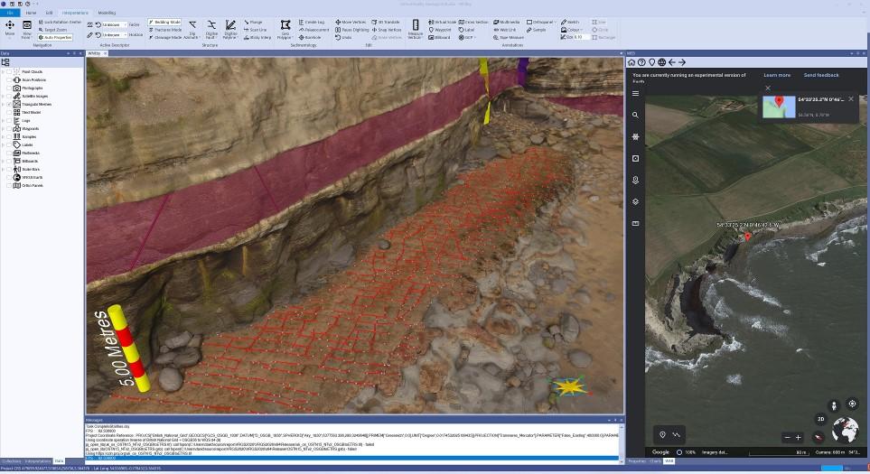
Interpret directly on the outcrop at every scale
Work with point clouds or meshes and digitise structure straight onto the model. Colour by surface attributes, extract orientations automatically, and move seamlessly from regional context down to millimetre detail.
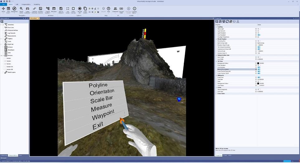
Step inside your outcrop
Put on a headset and walk the outcrop at true scale. Measure, digitise and annotate in three dimensions using the in-VR tool menu, then bring the same interpretation straight back to the desktop.
Depth where it matters
VRGS underpins quantitative, defensible workflows across the verticals shaping subsurface geoscience.
Mining & geotechnical
Fracture and discontinuity mapping, stereonet analysis and DFN inputs for slope stability and rock-mass characterisation.
Geothermal & EGS
Characterise fracture networks and stress fields for enhanced geothermal systems and reservoir performance.
Carbon capture & storage
Build caprock-integrity and fault-seal analogue workflows for secure, well-understood CO₂ storage.
Hydrogen & energy storage
Characterise salt and reservoir analogues for safe subsurface hydrogen and energy storage.
Equally at home in research and the classroom. VRGS is used in peer-reviewed science and immersive teaching worldwide.
Share your science with the world
outcrop.io is the digital outcrop repository. A cloud platform to publish, explore and collaborate on high-resolution 3D geological models. Built on FAIR principles and AI-native from the ground up.
Developed by geoscientists. Trusted in research and practice.
VRGS is built by a geoscientist and software engineer, and underpins peer-reviewed publications in active collaboration with universities and industry.
Peer-reviewed science
VRGS underpins published research and is developed in active collaboration with universities and industry partners.
A spin-out with pedigree
VRGeoscience is a spin-out from the University of Manchester’s Innovation Factory, founded by Dr David Hodgetts.
Built by a geoscientist
Designed and engineered by someone who does the science so results are not only visual, but scientifically robust.
Evaluate VRGS on your own data
Start a free 30-day trial and run a full interpretation on your own models — desktop or VR, with or without a headset.