Preserve Geological Detail: How to Link High-Res Images to 3D Models
Digital outcrop models have transformed the way geologists visualise and interpret rock exposures. By combining high-resolution imagery with detailed 3D geometry, they enable remote, accurate, and repeatable analysis of complex geological features.

By David Hodgetts
Published On 2025-05-20
Last Edited : 2025-05-20
Preserve Geological Detail: How to Link High-Res Images to 3D Models

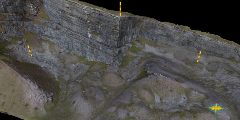
Digital outcrop models provide a highly detailed representation of outcrops, enabling geologists to interpret geological features with unprecedented clarity and precision. As outcrop models have grown larger, both in terms of surface area and the number of triangles in the mesh, thanks to advances in computing power and photogrammetric processing, they now capture fine-scale geological structures at resolutions once only possible through direct field observation.
The increased fidelity of outcrop models has expanded their use in structural geology, sedimentology, geotechnical analysis, and education, allowing for comprehensive, remote interpretation of complex geological features. This increased model complexity also brings new challenges in data handling, texture quality, and interpretation workflows, particularly when working with large datasets or attempting to preserve the detail of original imagery. As a result, we’re increasingly being asked:
“Why don’t the textures on my outcrop model look as clear and detailed as the original images, and is there any way to improve this?”
To answer this question, we first need to understand what an outcrop model comprises. An outcrop model is typically made up of 2 parts: the mesh and the texture.
Textures and Meshes.
The mesh is the 3D geometric framework that represents the shape and surface structure of the outcrop. It is composed of a network of connected vertices, edges, and faces—typically arranged as triangles—that together form a continuous surface. The mesh will vary in resolution depending on the data quality and processing settings, and finer meshes have more triangles and can represent detailed surface features more accurately, but also require more computational resources.
The texture refers to a 2D image or set of images mapped onto the surface of a 3D mesh to visually replicate the appearance of the real-world outcrop. These textures are derived from high-resolution photographs taken during field data collection, and they provide the detailed colour and visual information that gives the 3D model a photo-realistic appearance.
Textures are essential for geological interpretation, as they allow users to visually identify features that are not evident from the 3D geometry alone.
Digital outcrop models are typically created using hundreds to thousands of high-resolution digital images. During the processing, these images undergo resampling and compression, often leading to a noticeable reduction in texture quality. Consequently, the resulting textures applied to 3D outcrop models lack the clarity and detail found in the original photographs.
This issue is particularly significant for geologists and researchers who rely on digital outcrop models for detailed geological analysis. Reduced texture resolution can limit the ability to observe and interpret fine-scale geological features accurately, which is essential in structural, sedimentological, and engineering assessments. This resolution mismatch thus poses challenges for detailed geological interpretation and analysis.
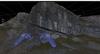
To illustrate this, let us consider an example taken from the Trefor Rocks model:

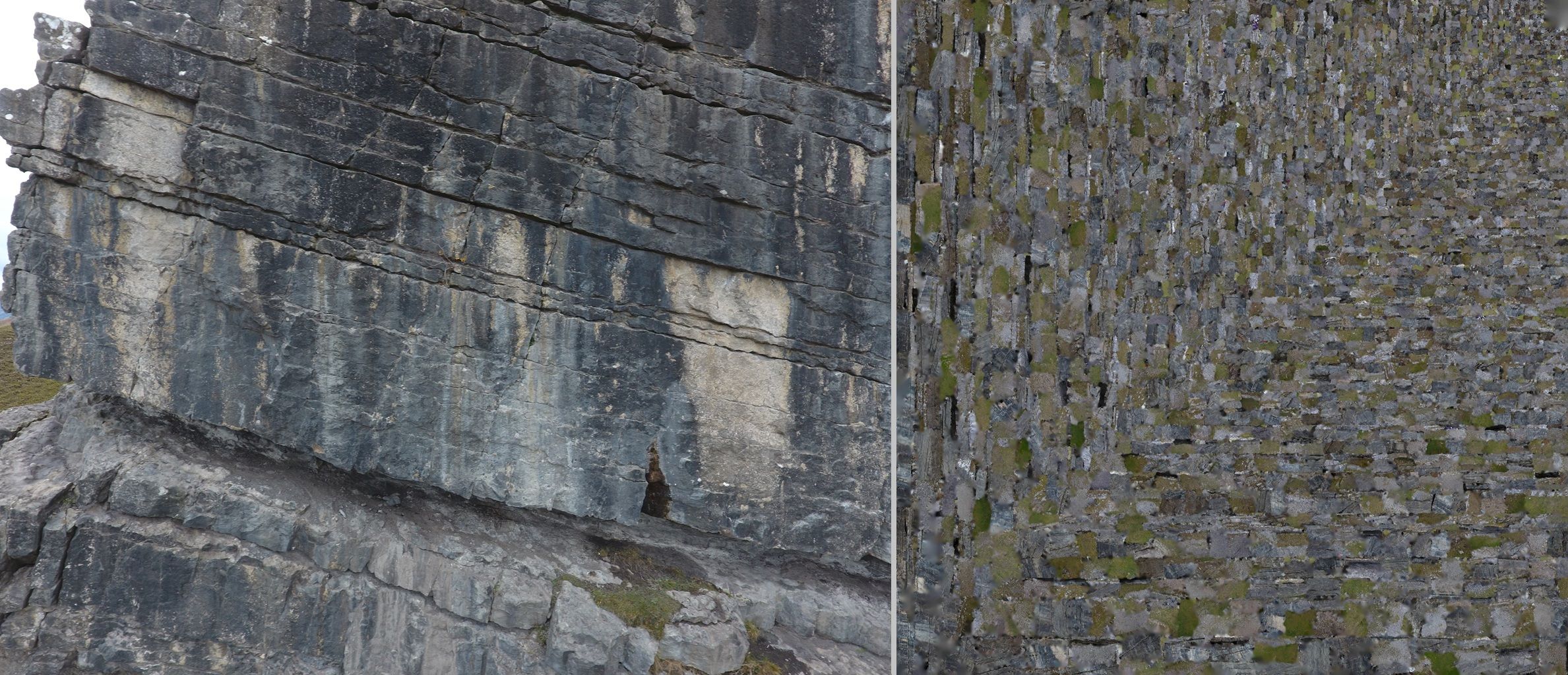
Comparison between a high-resolution source image of an outcrop (left) and the texture map generated during 3D model creation (right). The texture map is composed of many small image fragments reorganised to maximise texture space efficiency, which often results in a loss of visual coherence and detail compared to the original image.
The first image shows a high-resolution photograph of an outcrop, revealing clear and detailed geological features such as bedding planes, fractures, and weathering patterns.
In contrast, the second image presents a texture map created during the model generation process, comprising numerous small, fragmented sections of multiple original images. This fragmented and compressed texture demonstrates why textures on 3D models often fail to match the visual quality and clarity of the original imagery, making detailed geological interpretations challenging.
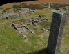
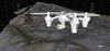
The second pair of images illustrates the complexity involved in mapping textures onto an outcrop model. The bottom image displays the outcrop model itself, while the top image visualises the intricate patchwork of individual image fragments that compose its texture.

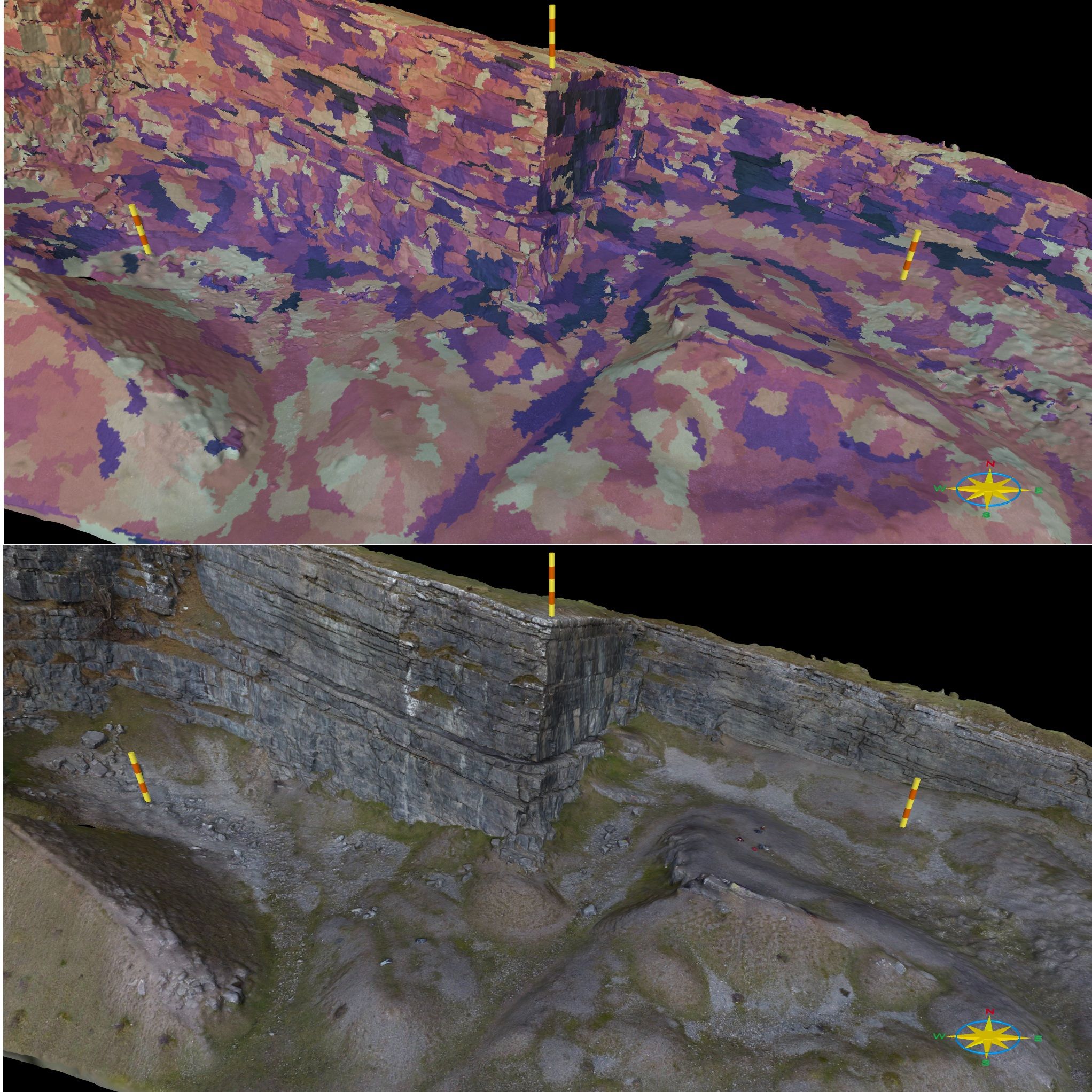
Top: Visualisation of texture patches used in an outcrop model, showing how image fragments are mapped irregularly across the surface. Bottom: Fully textured outcrop model, where the original high-resolution imagery has been applied to give a photorealistic appearance. This contrast highlights the complexity behind texture mapping and the importance of retaining image fidelity for geological interpretation.
Texture fragments are sorted primarily to maximise efficiency in texture usage, rather than preserving spatial coherence. Consequently, patches that are side-by-side on the 3D model may be dispersed throughout the texture map. This non-contiguous arrangement complicates direct manipulation and analysis of texture data and can introduce artefacts or inaccuracies, particularly when performing automated mapping or interpretations directly on the texture map.
To address this challenge, VRGS utilises Pix4D's Open Photogrammetry Format (OPF), a powerful format that allows new approaches and technologies to be developed based on photogrammetric outputs.
What is the OPF?
The Open Photogrammetry Format (OPF) by Pix4D is a structured format designed to store and share photogrammetry projects. It encapsulates original images, camera parameters, geospatial information, and project metadata into a single, accessible, and interoperable package. This ensures data integrity, facilitating advanced interpretations directly on source images.
By using information from the OPF, we can now import the imagery into VRGS and interpret the original images while having the interpretations linked directly to the outcrop model. By bridging the gap between high-resolution imagery and 3D visualisation, we can ensure that geologists can conduct more accurate, detailed, and reliable geological analyses.
Pix4D Labs: Meet OPF - the PDF of photogrammetry | Pix4D
Why is this a breakthrough for geology?
Fine-scale features, whether structural (fractures, faults, folds), sedimentological (cross-bedding, lamination, trace fossils), or engineering-related (joint spacing, rock quality), are often blurred or entirely lost on textured 3D models. Traditional digital outcrop modelling usually relies on imagery that has been resampled or compressed, leading to a significant loss of critical geological details. Such limitations can dramatically reduce your ability to accurately interpret small-scale geological features.
Conclusion:
By leveraging Pix4D’s OPF in VRGS, geologists gain a powerful tool to enhance the precision and quality of their interpretations. Annotating directly on original high-resolution imagery preserves essential details, enabling comprehensive and accurate analysis of:
• Structural features, providing clearer fracture mapping, fault geometry, and deformation patterns.
• Sedimentological characteristics, aiding precise reconstructions of depositional environments and paleocurrent directions.
• Engineering geological assessments, facilitating detailed evaluations of rock stability, joint spacing, and material quality.
This approach significantly boosts confidence in geological interpretations and ultimately improves decision-making across exploration, research, hazard assessment, and resource management.
Now you can capture geological details exactly as you observe them, ensuring the highest quality geological insights and outcomes.
#Geology #StructuralGeology #Sedimentology #EngineeringGeology #DigitalOutcrop #VRGS #Pix4D #OPF
Latest Articles