Point Clouds, Textured Meshes or Tiled Models?
Point clouds, textured meshes, and tiled models, each with their unique strengths and challenges, are crucial components of digital outcrop modelling. Although they each have individual pros and cons, their synergy often leads to the most rewarding results.

By David Hodgetts
Published On 2023-07-24
Point Clouds, Textured Meshes or Tiled Models?


Point Clouds, Textured Meshes or Tiled Models?
Geoscience has embraced the digital age with digital outcrop modelling (DOM), offering a way to explore and analyse geological formations in a 3D environment. The data types typically used for digital outcrop modelling are point clouds, tiled models, and textured meshes, each contributing uniquely to the process and bringing their own strengths and challenges. In this blog post, we will delve into these data types, examining their applications in DOM and the complexities they navigate, including tile boundary issues and the need for highest-resolution interpretations.
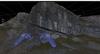
Point Clouds: The Backbone of Precision
Acting as the "bedrock" of digital outcrop modelling, point clouds provide a dense collection of data points gathered via LiDAR scanning or photogrammetry. Each point signifies a specific spot on the geological formation, leading to a highly detailed 3D representation.
The primary advantage of point clouds lies in their ability to encapsulate extremely high-resolution data, ideal for tasks requiring meticulous precision such as volume calculations or distance measurements. Particularly when using lidar data, the points represent the actual data from the scanner, so you know the vertex you are picking is actual data, rather than an interpolation of vertex positions you get with the triangles of a mesh. This data density can result in sizable files that demand robust storage solutions and powerful processing capabilities. Furthermore, point clouds only contain spatial data points, lacking inherent information about surfaces or textures — a limitation when a complete visualisation of the outcrop is required. Interpreting point clouds can be difficult as you can easily pick through a surface to a surface further back and end up with strange interpretations. As they represent the actual data, point clouds are increasingly being used for quantitative analysis and classification, from surface attributes through to multi and hyperspectral data.
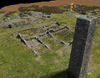
Textured Meshes: Adding Realism to Geology
To add a touch of realism to the geometric structures in DOM, textured meshes come into play. By incorporating surface data and textures, they create visually engaging and realistic representations of outcrops, vital for understanding not only the form but also the visible geological traits of the outcrop.
While textured meshes offer the advantage of aesthetics, their creation can be complex, requiring advanced software and potentially manual intervention for refinement. Moreover, high-quality meshes can affect real-time applications' performance, such as VR or AR, increasingly used in geoscience education and research.
Mesh data is much easier to visualise and interpret than point cloud data as it is more like what we are used to in the real world. Interpreting on a solid mesh surface is easier and requires less precision than a point cloud. The position information selected by clicking on a triangle is an interpolation of the vertex points, and as such is not the true position. In many cases the difference is insignificant, but in certain instances where the point spacing is large compared to the variability in the surface the errors can be significant. This can be a problem when dealing with fracture studies, and why you should always be careful when decimating data. This is why VRGS does not decimate data by default.
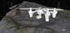
Tiled Models: The Solution for Large-Scale Projects
For expansive geological formations that present a challenge for a single digital model, tiled models have emerged as one solution. By breaking the model into manageable 'tiles' at distinct levels of detail, they enable more efficient handling of large datasets.
Tiled models bring scalability and performance to the table. They facilitate efficient loading of complex scenes and enhance rendering performance through effective culling and level-of-detail operations. They also introduce unique challenges, notably in managing tile boundaries during processing. When computations or analyses need a continuous surface, interruptions at tile boundaries can also lead to inaccuracies. Due to the way the tiled models function, the entire high-resolution model may never be in memory at the same time, making whole model analysis difficult. Though it is possible to generate attributes such as coplanarity for a tiled model dataset, the computational requirements of doing this on-the-fly, or the increased overhead of the file size of pre-processed attributes, would severely impact tiled model performance.
Interpreting geological features at the highest model resolution is critical, particularly with tiled models. The highest-resolution tiles hold the most detailed data, enabling the most accurate interpretations. It is common to see a mismatch in interpretation and model, as the interpretation had been made on a lower resolution tile than the one displayed.
Furthermore, inconsistencies in data resolution or discrepancies across tiles can cause visible seams or artefacts, complicating rendering, especially in real-time applications requiring consistent performance across tiles. Addressing these challenges often requires advanced algorithms to ensure seamless transitions, manage resolution discrepancies, and facilitate interpretation at various detail levels, adding to the complexity and resource demands of creating and managing tiled models.
The Nanite approach
Nanite is a virtualised geometry technology developed by Epic Games for Unreal Engine 5. This technology enables developers to create and utilise incredibly detailed 3D assets, known as Nanite meshes, that consist of millions or even billions of polygons.
What sets Nanite apart is its ability to stream and scale these highly detailed assets in real time without sacrificing performance, with the full dataset in core. It can automatically provide the highest level of detail possible based on what the camera sees and the proximity of the objects in the scene. This helps to maintain the performance while providing breathtakingly detailed visuals.
This level of detail previously required significant resources to render and was used for pre-rendered scenes or high-quality static images. With Nanite, these assets can now be used in real-time game environments, significantly increasing the potential for realism and detail in video games.
Though Nanite is an amazing technology it is currently only available as part of Unreal Engine 5 (and above), though this demonstrates the (possible) future of mesh visualisation.
Conclusion: A Synergistic Approach for Geological Analysis
Point clouds, textured meshes, and tiled models, each with their unique strengths and challenges, are crucial components of digital outcrop modelling. Although they each have individual pros and cons, their synergy often leads to the most rewarding results. For instance, using point cloud data as a base to create a textured mesh, which can then be subdivided into tiles for optimal performance, can provide a comprehensive solution.
As technological advancements continue to evolve these techniques, they are expected to become more integrated, flexible, and efficient. Understanding their strengths and limitations allows geoscientists to choose the most appropriate tools for their projects, pushing the boundaries of discovery and understanding in the captivating realm of geology.
Despite the complexities, the union of point clouds, textured meshes, and tiled models provides unparalleled opportunities in digital outcrop modelling. For instance, interpreting high-resolution tiled models can offer insights into minute geological features, while textured meshes and point clouds allow full-model analysis.
Each challenge faced, whether it is managing large data files from point clouds or negotiating tile boundaries in large models, also prompts the development of more sophisticated algorithms and solutions. The field is constantly evolving and adapting in response to these challenges, as seen by Unreal Engines Nanite meshes, leading to more effective and innovative methods of studying 3D geospatial datasets.
To sum up, the interplay of point clouds, textured meshes, and tiled models is shaping the future of digital outcrop modelling. As these techniques continue to advance and become more streamlined, they will undoubtedly continue to revolutionise the way we study and interact with geology.
Latest Articles